The State of Vermont was mapped in extraordinary detail 150 years
ago. Between 1854-1859 mapmakers from Philadelphia and Boston descended
upon this rural area and made the first complete road maps.[1]
The results of their work were eleven large wall maps. Not only were
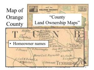
all the roads mapped for the first time, but these maps showed the names
and locations of all homes, churches, schools and businesses.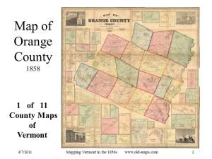
These
old maps are a remarkable snapshot of a moment in time in Vermont’s
history. No maps today are made with the sort of detail these 19th
century mapmakers made for us. Today the 1850s maps help us learn who
lived in our houses in centuries past or whose house once set upon an
old foundation far off into the woods.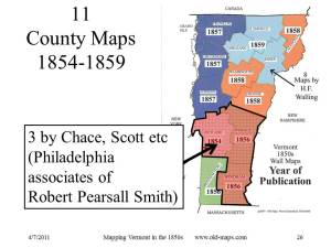
And
of course these maps are a huge resource for genealogists because of
the names – 1000s of names attached to the house locations. I estimate
between three and five thousand names are on each of Vermont’s 11 large
county wall maps.
These were commercial maps – made by business men from Boston and Philadelphia. The Vermont maps were just part of a wave of similar maps made of most of the United States and all of the populated northeast. Though my subject is Vermont, the material generally applies to the other New England states. All of NH, Mass and CT were mapped in the same manner in the same decade.
Changes in printing technology, a
growing middle class, and railroad transportation preceded the county
map boom in America. The mechanics of printing was especially
important. Prior to the mid 1800s, printed maps were rarely made of
local areas such as towns or counties. Map making was expensive, and
you typically needed a broader subject like an entire ountryo generate
enough sales to make a profitable venture. Maps were engraved in reverse
on metal plates by hand. This was a laborious process, and could only
be done by skilled craftsmen. 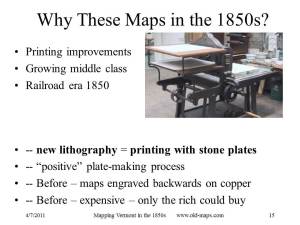
About
1850 lithography, printing on large limestone plates, became widely
available along with a positive transfer process which allowed the map
to be drawn in its final form. This and other changes made short-run
printing of maps much less expensive.

The
first Vermont county map was of Rutland County, published in 1854 by
Jacob Chace Jr. and James Scott of Philadelphia. These men had just
issued a county map of nearby Washington County New York which they
showed in Rutland. The surveys, conducted by Chace, began in June of
1853. We
know this because advertising started on June 18 in the Rutland
newspaper and continued for six months. Mapmaking was expensive so 19th
century mapmakers took advance orders, often while they did the
surveys. The surveyor used a compass to record angles and a wheeled
odometer for distances. The odometer and compass and the surveyor who
carried them were an unusual sight in rural Vermont, a fact which no
doubt helped the sales efforts. The surveyor would ask th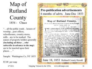 e name of each
homeowner and tell him that the map would feature his name and his
house, and wouldn’t he like to buy a copy. The price was five dollars, a
considerable amount of money at the time. Publication was announced a
year after the project started. “It is a large…and very accurate map…”
announced the Rutland County Herald on June 9th, 1854. That
claim notwithstanding, the Rutland County 1854 map is in fact among the
least accurate of the Vermont county wall maps. Chace and Scott were not
the best mapmakers publishing in Vermont in the 1850s. More on accuracy
later.
There were two major figures in 1850s county map
publishing, Robert Pearsall Smith and Henry Francis Walling. The most
prolific was Smith, a Philadelphian who printed over 300 county maps
with dozens of surveyors and publishers, including Chace and Scott.
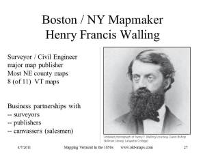 The other was Henry F. Walling of Boston (and later New York), a
professional engineer who produced dozens of New England town maps and
about fifty county wall maps. His training and inclination led to the
publication of maps which are generally more accurate than those made in
Philadelphia. Three Vermont county maps were made by associates of
Smith and eight were made by Walling. There was tension between the
competing mapmakers. For example, Walling intended to map Windsor
County but was pre-empted by Smith who copyrighted his county map
(surveyed by Hosea Doton) in April, 1856. Walling had announced his map
in the fall of 1854 with a paid advertisement describing the quality of
his work and warning that “parties from Philadelphia are …publishing
county maps from mere eye-sketches…entitled to no confidence…” The
problem for Walling may have been that his maps took more time to
produce – he never issued a Windsor County map. The timetable for
Walling’s 1858 Caledonia County map is instructive. It too was
announced in late 1854 (with a warning about the Philadelphians). The
final map was copyrighted in August 1858 almost four years later. His
Chittenden County map took about two and a half years, still longer than
the Philadelphia mapmakers’ single year. Walling's reference to “mere
eye sketches” was a way to contrast the surveying methods used by the
competing mapmakers. Walling is known to have used proper surveying
techniques with careful measurements of angles and distances and
adjusting the various road survey loops to remove as many errors as
possible. A less careful mapmaker would not bother the tedious
adjustments, and would do some of his mapping by skipping the compass
and odometer work if he could see the roads stretching out before him –
using "eye-sketches" - which was possible in 1850s Vermont.
[1] Prior to these wall maps there were a few detailed road maps made for Vermont’s larger town centers, such as Burlington, Rutland, and Brattleboro, but the most of the states roads were unmapped. The federal government's road mapping (topographic maps) did not begin until the end of the 19th century.
