Loading... Please wait...
 Categories
Categories
- World Maps
- Books
- Calendars
- Topographical Maps
- Alabama
- Arkansas
- California
- Canada
- Colorado
- Delaware
- Arizona
- Connecticut
- CT - NY
- DE - NJ - PA
- Florida
- GA - FL
- Georgia
- Hawaii
- Idaho
- Illinois
- Indiana
- Iowa
- Kansas
- Kentucky
- Louisiana
- Maine
- Maryland
- Massachusetts
- MD - VA
- Michigan
- Minnesota
- Mississippi
- Missouri
- Montana
- NC - SC
- Nebraska
- Nevada
- New Hampshire
- New Jersey
- New Mexico
- New York
- NH - MA - RI
- North Carolina
- North Dakota
- Ohio
- Oklahoma
- Oregon
- Pennsylvania
- Rhode Island
- South Carolina
- South Dakota
- Tennessee
- Texas
- Utah
- Vermont
- Virginia
- Washington DC & Maryland Custom Topographic Maps
- Washington State
- West Virginia
- Wisconsin
- Wyoming
- Nautical Charts
- Atlantic Coast
- 400,000 Scale Charts
- 80,000 Scale Charts
- Alabama - Louisiana
- Albemarle & Pamlico Sounds
- Cape Hatteras to Amelia Island
- Chesapeake Bay
- Chesapeake Bay 80,000 Scale Custom Nautical Charts
- Custom
- Delaware, Maryland, Virginia
- Florida
- Florida 80,000 Scale Custom Nautical Charts
- New Engand
- NC-GA 80,000 Scale Custom Nautical Charts
- New England
- New England 80,000 Scale Custom Nautical Charts
- New Jersey
- New York
- New York 80,000 Scale Custom Nautical Charts
- Rhode Island 80,000 Scale Custom Nautical Charts
- Texas
- Texas 80,000 Scale Custom Nautical Charts
- General Charts
- Big Area Charts
- Harbor Charts
- Great Lakes
- All 5 Lakes
- Great Lakes Harbors
- Lake Erie Harbor Charts
- Detroit and St Clair Rivers Harbor Charts
- Lake Huron Harbor Charts
- Lake Michigan Harbor Charts
- Lake Ontario Harbor Charts
- Lake Superior Harbor Charts
- Minnesota-Ontario Border Lakes
- Northwest Lake Huron Harbor Charts
- St. Lawrence River Harbor Charts
- St. Lawrence River - Small Harbor Charts
- Great Lakes Survey - First Series
- Individual Lakes
- New York Canals & Lakes
- Other
- Inland Lakes
- Lake Champlain
- Pacific Coast
- Shipwreck Maps
- Panama Canal
- Atlantic Coast
- Fire Insurance Maps
- Geological Maps
- Alabama
- Alaska
- Arizona
- New England Maps
- Arkansas
- California
- Central America - Caribbean
- Colorado
- Connecticut
- Bird's Eyes
- City Maps
- County Map CDs - CT
- County Maps
- State Maps
- Towns
- Fairfield Co. CT - 1856 Town
- New Haven Co. CT - 1856 Town
- Fairfield Co. CT - 1858 Town
- Hartford Co. CT - 1855 Town
- Hartford & Vicinity CT - 1884 Town
- Hartford Co. CT - 1869 Town
- Litchfield Co. CT - 1859 Town
- Middlesex Co. CT - 1859 Town
- Middlesex Co. CT - 1874 Town
- New Haven Co. CT - 1852 Town
- New Haven Co. CT - 1868 Town
- New London Co. CT - 1854 Town
- Tolland Co. CT - 1857 Town
- Tolland Co. CT - 1869 Town
- Windham Co. CT - 1856 Town
- Delaware
- Florida
- Georgia
- Hawaii
- Idaho
- Illinois
- 1876 Warner & Beers State Atlas
- Bird's Eyes
- Cities
- County Wall Maps - IL
- State Maps
- Towns
- Adams Co. IL - 1889 Town
- Carroll Co. IL - 1869 Town
- Christian Co. IL - 1872 Town
- Christian Co. IL - 1893 Town
- Cook & Dupage Cos. IL - 1890 Town
- Cook Co. IL - 1861 Town
- Cook Co. IL - 1886 Town
- Cook, Dupage, & Will Cos, IL - 1898 Town
- DeKalb Co. IL - 1860 Town
- Edgar Co. IL - 1870 Town
- Edwards Co. IL - 1891 Town
- Franklin Co. IL - 1900 Town
- Greene Co. IL - 1861 Town
- Hancock Co. IL - 1859 Town
- Iroquois & Kankakee Cos. IL - 1860 Town
- Jefferson Co. IL - 1900 Town
- Kane Co. IL - 1860 Town
- Knox Co. IL - 1861 Town
- Lake Co. IL - 1861 Town
- Lake Co. IL - 1873 Town
- LaSalle Co. IL - 1895 Town
- Logan Co. IL - 1893 Town
- Madison Co. IL - 1892 Town
- McHenry Co. IL - 1862 Town
- Peoria Co. IL - 1861 Town
- Pike Co. IL - 1860 Town
- St. Clair Co. IL - 1863 Town
- St. Clair Co. IL - 1899 Town
- Stephenson Co. IL - 1859 Town
- White Co. IL - 1871 Town
- Whiteside Co. IL - 1896 Town
- Will Co. IL - 1862 Town
- Winnebago Co. IL - 1859 Town
- Indiana
- Bird's Eyes
- City Maps
- State Maps
- County Wall Maps - IN
- Indiana Lakes Maps
- Towns
- Boone Co. IN - 1865 Town
- Carroll Co. IN - 1897 Town
- Carroll Co. IN - 1898 Town
- Clark Co. IN - 1875 Town
- Clinton Co. IN - 1865 Town
- Dearborn Co. IN - 1860 Town
- Decatur Co. IN - 1867 Town
- DeKalb Co. IN - 1863 Town
- Floyd Co. IN - 1859 Town
- Floyd Co. IN - 1882 Town
- Fountain Co. IN - 1865 Town
- Grant Co. IN - 1861 Town
- Hamilton Co. IN - 1866 Town
- Hendricks Co. IN - 1865 Town
- Henry Co. IN - 1857 Town
- Huntington Co. IN - 1866 Town
- Jefferson Co. IN - 1900 Town
- Johnson Co. IN - 1866 Town
- Kosciusko Co. IN - 1866 Town
- Laporte Co. IN - 1862 Town
- Marion Co. IN - 1855 Town
- Marion Co. IN - 1866 Town
- Montgomery Co. IN - 1864 Town
- Morgan Co. IN - 1875 Town
- Noble Co. IN - 1860 Town
- Perry Co. IN - 1894 Town
- Putnam Co. IN - 1864 Town
- Randolph Co. IN - 1865 Town
- Rush Co. IN - 1856 Town
- Rush Co. IN - 1867 Town
- Shelby Co. IN - 1866 Town
- Starke Co. IN - 1898 Town
- St. Joseph Co. IN - 1863 Town
- Tippecanoe Co. IN - 1866 Town
- Vermillion Co. IN - 1872 Town
- Vigo Co. IN - 1858 Town
- Wabash Co. IN - 1861 Town
- Warren Co. IN - 1865 Town
- Whitley Co. IN - 1873 Town
- Iowa
- Bird's Eyes
- City Maps
- County Wall Maps - IA
- State Atlas
- State Maps
- Towns
- Adams Co. IA - 1884 Town
- Allamakee Co. IA - 1872 Town
- Black Hawk Co. IA - 1887 Town
- Buchanan Co. IA - 1900 Town
- Buena Vista Co. IA - 1884 Town
- Butler Co. IA - 1897 Town
- Calhoun Co. IA - 1884 Town
- Carroll Co. IA - 1884 Town
- Cedar Co. IA - 1863 Town
- Cherokee Co. IA - 1884 Town
- Clay Co. IA - 1896 Town
- Clinton Co. IA - 1865 Town
- Crawford Co. IA - 1883 Town
- Dallas Co. IA - 1883 Town
- Delaware Co. IA - 1869 Town
- Dickinson Co. IA - 1883 Town
- Dubuque Co. IA - 1900 Town
- Hamilton Co. IA - 1883 Town
- Jackson Co. IA - 1867 Town
- Jasper Co. IA - 1871 Town
- Jefferson Co. IA - 1871 Town
- Keokuk Co. IA - 1861 Town
- Linn Co. IA - 1881 Town
- Mahaska Co. IA - 1871 Town
- Marshall Co. IA - 1896 Town
- Monona Co. IA - 1884 Town
- O'Brien Co. IA - 1884 Town
- Plymouth Co. IA - 1884 Town
- Polk Co. IA - 1885 Town
- Sioux Co. IA - 1884 Town
- Story Co. IA - 1883 Town
- Wapello Co. IA - 1870 Town
- Warren Co. IA - 1859 Town
- Woodbury Co. IA - 1884 Town
- Wright Co. IA - 1885 Town
- Kansas
- Kentucky
- Bird's Eyes
- State Maps
- Cities
- County Wall Maps - KY
- Towns
- Barren Co. KY - 1877 Town
- Bourbon Co. KY - 1861 Town
- Boyle Co. KY - 1876 Town
- Christian Co. KY - 1878 Town
- Clark Co. KY - 1861 Town
- Fayette Co. KY - 1861 Town
- Garrard Co. KY - 1879 Town
- Harrison Co. KY - 1877 Town
- Jessamine Co. KY - 1861 Town
- Lincoln Co. KY - 1879 Town
- Madison Co. KY - 1876 Town
- Marion Co. KY - 1877 Town
- Mercer Co. KY - 1876 Town
- Montgomery Co. KY - 1879 Town
- Scott Co. KY - 1879 Town
- Washington Co. KY - 1877 Town
- Warren Co. KY - 1877 Town
- Woodford Co. KY - 1861 Town
- Louisiana
- Maine
- 1837 Coast Charts
- Acadia National Park Prints
- Bird's Eyes
- City Maps
- Coastline
- County Maps - Other
- County Wall Maps - ME
- Maine Lakes
- Map CDs - ME
- Mt. Desert Island & Bar Harbor Prints
- Regional
- State Atlases
- State Maps
- Towns
- Androscoggin Co. ME - 1858 Town
- Androscoggin Co. ME - 1873 Town
- Aroostook Co. ME - 1877 Town
- Cumberland Co. ME - 1857 Town
- Cumberland Co. ME - 1871 Town
- Franklin Co. ME - 1861 Town
- Hancock Co. ME - 1860 Town
- Kennebec Co. ME - 1856 Town
- Lincoln Co. ME - 1857 Town
- Oxford Co. ME - 1858 Town
- Penobscot Co. ME - 1859 Town
- Piscataquis Co. ME - 1858 Town
- Sagadahoc Co. ME - 1858 Town
- Somerset Co. ME - 1860 Town
- Waldo Co. ME - 1859 Town
- Washington Co. ME - 1861 Town
- York Co. ME - 1856 Town
- Maryland
- Bird's Eyes
- Chesapeake Bay Maps
- City Maps
- County Map CDs - MD
- County Maps - Other
- County Wall Maps - MD
- State Atlases
- State Maps
- Towns
- Anne Arundel Co. & Vicinity - 1878 Towns
- Anne Arundel Co. MD - 1860 Town
- Baltimore Co. MD - 1857 Town
- Carroll Co. MD - 1862 Town
- Cecil Co. MD - 1858 Town
- Frederick Co. MD - 1858 Town
- Harford Co. MD - 1878 Town
- Howard Co. MD - 1860 Town
- Kent Co. MD - 1860 Town
- Montgomery Co. MD - 1865 Town
- Montgomery Co., DC & Vicinity - 1879 Towns
- Wicomico, Somerset, Worcester Cos. MD - 1877 Town
- Massachusetts
- Aerial Photos
- Bird's Eyes
- Boston Early Maps
- Boston Maps
- Cape Cod
- City Maps - Not Boston
- County Map CDs - MA
- County Maps - 1844 Borden
- County Maps - 1861 Walling
- County Maps - MA
- County Maps - Other
- Harbor & Land Commission Boundary Atlases
- State Atlases
- State Highway Maps
- State Maps
- Towns
- Massachusetts Archive 1794 Town Prints
- Massachusetts Archive 1830s Town Prints
- Town Posters
- Barnstable Co. MA - 1858 Town
- Barnstable Co. MA - 1910 Town
- Berkshire Co. MA - 1858 Town
- Berkshire Co. MA - 1876 Town
- Berkshire Co. MA - 1904 Town
- Boston MA & Vicinity - 1852 Town
- Bristol Co. MA - 1858 Town
- Bristol Co. MA - 1895 Town
- Brookline 1874
- Brookline 1927
- Cambridge 1873
- Cambridge 1886
- Cambridge 1930
- Deerfield MA - 1855 Town
- Essex Co. MA - 1856 Town
- Essex Co. MA - 1872 Town
- Essex Co. MA - 1919 Town - Beverly & Manchester
- Franklin Co. MA - 1832 Town
- Franklin Co. MA - 1858 Town
- Franklin Co. MA - 1871 Town
- Hampden Co. MA - 1857 Town
- Hampden Co. MA - 1870 Town
- Hampden Co. MA - 1894 Town
- Hampden Co. MA - 1912 Town
- Hampshire Co. MA - 1856 Town
- Hampshire Co. MA - 1873 Town
- Hampshire Co. MA - 1860 Town
- Middlesex Co. MA - 1856 Town
- Middlesex Co. MA - 1875 Town
- Middlesex Co. Vol. 1 - Cambridge Area - 1900
- Middlesex Co. Vol. 2 - Concord to Wakefield 1906
- Norfolk Co. MA - 1858 Town
- Norfolk Co. MA - 1876 Town
- Plymouth Co. MA - 1857 Town
- Plymouth Co. MA - 1879 Town
- Plymouth Co. MA - 1903 Town
- Worcester Co. MA - 1857 Town
- Worcester Co. MA - 1870 Town
- Towns - Part Of
- Michigan
- Bird's Eyes
- State Maps
- Cities
- County Wall Maps - MI
- Towns
- Barry Co. MI - 1860 Town
- Gratiot Co. MI - 1864 Town
- Berrien Co. MI - 1860 Town
- Branch Co. MI - 1858 Town
- Calhoun Co. MI - 1858 Town
- Cass Co. MI - 1860 Town
- Cass Co. MI - 1897 Town
- Clinton Co. MI - 1864 Town
- Eaton Co. MI - 1860 Town
- Genesee Co. MI - 1859 Town
- Gartiot Co. MI - 1864 Town
- Gratiot Co. MI - 1876 Town
- Hillsdale Co. MI - 1857 Town
- Huron Co. MI - 1875 Town
- Ingham Co. MI - 1859 Town
- Ionia Co. MI - 1861 Town
- Jackson Co. MI - 1858 Town
- Kalamazoo Co. MI - 1861 Town
- Kalkaska Co. MI - 1898 Town
- Lake Co. MI - 1900 Town
- Lapeer Co. MI - 1863 Town
- Lenawee Co. MI - 1857 Town
- Livingston Co. MI - 1859 Town
- Macomb Co. MI - 1859 Town
- Monroe Co. MI - 1859 Town
- Montcalm Co. MI - 1875 Town
- Oceana Co. MI - 1876 Town
- Saginaw Co. MI - 1890 Town
- Sanilac Co. MI - 1876 Town
- Shiawassee Co. MI - 1859 Town
- St. Clair Co. MI - 1859 Town
- St. Joseph Co. MI - 1858 Town
- Van Buren Co. MI - 1860 Town
- Washtenaw Co. MI - 1856 Town
- Wayne Co. MI - 1860 Town
- Minnesota
- Bird's Eyes
- Cities
- County Wall Maps - MN
- Lake Minnetonka Maps
- State Maps
- Towns
- Blue Earth Co. MN - 1879 Town
- Brown Co. MN - 1886 Town
- Brown Co. MN - 1900 Town
- Carver Co. MN - 1880 Town
- Cottonwood Co. MN - 1898 Town
- Dakota Co. MN - 1874 Town
- Freeborn Co. MN - 1878 Town
- Hennepin Co. MN - 1879 Town
- Houston Co. MN - 1871Town
- Isanti Co. MN - 1898 Town
- LeSuer Co. MN - 1880 Town
- Lyon Co. MN - 1884 Town
- Martin Co. MN - 1901 Town
- Martin Co. MN- 1887 Town
- McLeod Co. MN - 1880 Town
- Murray Co. MN - 1898 Town
- Nicollet Co. MN - 1885 Town
- Pope Co. MN - 1901 Town
- Ramsey & Washington Counties - 1887 Town
- Ramsey Co. MN - 1885 Town
- Redwood Co. MN - 1898 Town
- Scott Co. MN - 1880 Town
- Sibley Co. MN - 1893 Town
- Steele Co. MN - 1879 Town
- Todd Co. MN - 1890 Town
- Watonwan Co. MN - 1898 Town
- Wright Co. MN - 1901 Town
- Mississippi
- Missouri
- Bird's Eyes
- Cities
- County Wall Maps - MO
- State Maps
- Towns
- Cass Co. MO - 1877 Town
- Cedar Co. MO - 1879 Town
- Cedar Co. MO - 1897 Town
- Clay Co. MO - 1887 Town
- Gasconade Co. MO - 1875 Town
- Grundy Co. MO - 1890 Town
- Henry Co. MO - 1877 Town
- Hickory Co. MO - 1880 Town
- Jackson Co. MO - 1887 Town
- McDonald Co. MO - 1884 Town
- Morgan Co. MO - 1880 Town
- Nodaway Co. MO - 1900 Town
- Pettis Co. MO - 1876 Town
- Saline Co. MO - 1871 Town
- St. Francois Co. MO - 1882 Town
- St. Louis Co. MO - 1880-1910 Town
- Vernon Co. MO - 1886 Town
- Montana
- Nebraska
- Nevada
- New Hampshire
- Aerial Photos
- Bird's Eyes
- City Maps
- County Maps - 1784 Holland
- County Maps - 1816 Carrigain
- County Wall Maps - NH
- Lakes
- Map CDs - NH
- State Atlases
- State Maps
- Towns
- Belknap Co. NH - 1860 Town
- Carroll Co. NH - 1861 Town
- Cheshire Co. NH - 1858 Town
- Cheshire Co. NH - 1877 Town
- Coos Co. NH - 1861 Town
- Grafton Co. NH - 1860 Town
- Hillsboro Co. NH - 1858 Town
- Merrimack Co. NH - 1858 Town
- Rockingham Co. NH - 1857 Town
- Strafford Co. NH - 1856 Town
- Strafford Co. NH - 1871 Town
- Sullivan Co. NH - 1860 Town
- White Mountains Maps
- New Jersey
- Bird's Eyes
- City Maps
- County Map CDs - NJ
- County Wall Maps - NJ
- State Maps
- Towns
- Atlantic Co. NJ - 1872 Town
- Monmouth Co. NJ - 1851 Town
- Ocean Co. NJ - 1872 Town
- Bergen & Passaic Co. NJ - 1861 Town
- Burlington Co. NJ - 1849 Town
- Burlington Co. NJ - 1859 Town
- Camden Co. NJ - 1857 Town
- Cape May Co. NJ - 1872 Town
- Cumberland Co. NJ - 1862 Town
- Essex Co. NJ - 1850 Town
- Essex Co. NJ - 1859 Town
- Essex Co. NJ - 1874 Town
- Gloucester Co. NJ - 1860 Town
- Hunterdon Co. NJ - 1851 Town
- Hunterdon Co. NJ - 1860 Town
- Mercer Co. NJ - 1849 Town
- Mercer Co. NJ - 1860 Town
- Mercer Co. NJ - 1875 Town
- Middlesex Co. NJ - 1850 Town
- Middlesex Co. NJ - 1861 Town
- Monmouth Co. NJ - 1861 Town
- Morris Co. NJ - 1853 Town
- NJ State Atlas - 1872 Town
- Salem & Gloucester Co. NJ - 1849 Town
- Somerset Co. NJ - 1850 Town
- Somerset Co. NJ - 1860 Town
- Sussex Co. NJ - 1860 Town
- Union Co. NJ - 1862 Town
- Warren Co. NJ - 1852 Town
- Warren Co. NJ - 1860 Town
- New Mexico
- New York
- Adirondack Maps
- Bird's Eyes
- Brooklyn Maps
- City Maps - Not NYC
- County Map CDs - NY
- County Maps - Other
- County Wall Maps - NY
- Long Island Maps
- New York City Maps
- New York Subway Maps
- NYC Area Maps
- NYC Small Areas
- Regionals
- Regionals - Canals
- Small County Maps
- Specials - Lakes
- State Atlases
- State Maps
- Staten Island Maps
- Towns
- Albany & Schenectady Cos. NY - 1866 Town
- Albany Co. NY - 1854 Town
- Allegany Co. NY - 1856 Town
- Broome Co. NY - 1855 Town
- Broome Co. NY - 1876 Town
- Cattaraugus Co. NY - 1856 Town
- Cayuga Co. NY - 1859 Town
- Cayuga Co. NY - 1875 Town
- Cayuga Co. NY - 1904 Town
- Chautauque Co. NY - 1854 Town
- Chautauqua Co. NY - 1867 Town
- Chemung Co. NY - 1853 Town
- Chemung Co. NY - 1869 Town
- Chenango Co. NY - 1855 Town
- Chenango Co. NY - 1863 Town
- Chenango Co. NY - 1875 Town
- Clinton Co. NY - 1856 Town
- Clinton Co. NY - 1869 Town
- Columbia Co. NY - 1851 Town
- Columbia Co. NY - 1873 Town
- Cortland Co. NY - 1855 Town
- Delaware Co. NY - 1856 Town
- Delaware Co. NY - 1869 Town
- Dutchess Co. NY - 1858 Town
- Erie Co. NY - 1855 Town
- Erie Co. NY - 1866 Town
- Erie Co. NY - 1880 Town
- Essex Co. NY - 1858 Town
- Essex Co. NY - 1876 Town
- Franklin Co. NY - 1858 Town
- Franklin Co. NY - 1876 Town
- Fulton Co. NY - 1856 Town
- Genesee Co. NY - 1854 Town
- Genesee Co., NY - 1876
- Greene Co. NY - 1856 Town
- Herkimer Co. NY - 1859 Town
- Hudson River Valley from NYC to Troy - 1891
- Jefferson Co. NY - 1855 Town
- Jefferson Co. NY - 1864 Town
- Kings & Queens Cos. NY - 1859 Town
- Kings & Queens Cos. NY - 1886 Town
- Lewis Co. NY - 1857 Town
- Lewis Co. NY - 1875 Town
- Livingston Co. NY - 1858 Town
- Long Island, NY - 1873 Towns
- Madison Co. NY - 1859 Town
- Madison Co. NY - 1875 Town
- Manhattan 1897 Atlas 1"=1800'
- Monroe Co. NY - 1852 Town
- Monroe Co. NY - 1858 Town
- Montgomery Co. NY - 1853 Town
- Montgomery & Fulton Cos. NY - 1868 Town
- New York City Port & Vicinity - 1857 Town
- Niagara Co. NY - 1852 Town
- Niagara Co. NY - 1860 Town
- Niagra & Orleans Cos., NY - 1875
- NYC & Environs - 1860 Town
- NYC & Vicinity - 1863 Town
- NYC & Vicinity - 1868 Town
- NYC Metro Area - 1891
- Oneida Co. NY - 1852 Town
- Onondaga Co. NY - 1852 Town
- Onondaga Co. NY - 1859 Town
- Ontario Co. NY - 1852 Town
- Ontario Co. NY - 1859 Town
- Orange Co. NY - 1859 Town
- Orange Co. NY - 1875 Town
- Orleans Co. NY - 1860 Town
- Oswego Co. NY - 1854 Town
- Oswego Co. NY - 1867 Town
- Otsego Co. NY - 1856 Town
- Otsego Co., NY - 1868
- Putnam Co. NY - 1854 Town
- Rensselaer Co. NY - 1861 Town
- Rockland Co. NY - 1859 Town
- Rural North of NYC - 1908 Town
- Saratoga Co. NY - 1856 Town
- Saratoga Co. NY - 1866 Town
- Schenectady Co. NY - 1856 Town
- Schoharie Co. NY - 1856 Town
- Schoharie Co. NY - 1866 Town
- Schuyler Co. NY - 1857 Town
- Schuyler Co., NY - 1874
- Seneca Co. NY - 1850 Town
- Seneca Co. NY - 1859 Town
- St. Lawrence Co. NY - 1858 Town
- St. Lawrence Co. NY - 1865 Town
- Steuben Co. NY - 1857 Town
- Steuben Co. NY - 1873 Town
- Suffolk Co. NY - 1858 Town
- Suffolk Co., NY - 1902 Atlas South Vol. 1
- Suffolk Co., NY - 1909 Atlas North Vol. 2
- Suffolk Co., NY - 1915-1917 Atlas Custom Prints
- Suffolk Co., NY - 1915 Atlas South Vol.1 - West
- Suffolk Co., NY - 1916 Atlas South Vol.2 - East
- Suffolk Co., NY - 1917 Atlas North Vol.1 - East
- Sullivan Co. NY - 1856 Town
- Sullivan Co. NY - 1875 Town
- Tioga Co. NY - 1855 Town
- Tompkins Co. NY - 1853 Town
- Tompkins Co. NY - 1866 Town
- Ulster Co. NY - 1853 Town
- Warren Co. NY - 1858 Town
- Warren Co. NY - 1876 Town
- Washington Co. NY - 1853 Town
- Wayne Co. NY - 1858 Town
- Wayne Co. NY - 1874 Town
- Westchester Co. NY - 1851 Town
- Westchester Co. NY - 1858 Town
- Westchester Co. NY - 1893 Town
- Wyoming Co. NY - 1853 Town
- Yates Co. NY - 1855 Town
- North Carolina
- North Dakota
- Ohio
- Bird's Eyes
- City Maps
- County Wall Maps - OH
- State Atlases
- State Maps
- Towns
- Allen Co. OH - 1880 Town
- Ashland Co. OH - 1861 Town - McDonnell
- Ashland Co. OH - 1861 Town - Nunan
- Ashland Co. OH - 1897 Town
- Ashtabula Co. OH - 1856 Town
- Athens Co. OH - 1875 Town
- Auglaize Co. OH - 1860 Town
- Brown Co. OH - 1876 Town
- Butler Co. OH - 1855 Town
- Champaign Co. OH - 1858 Town
- Champaign Co. OH - 1894 Town
- Clarke Co. OH - 1859 Town
- Clermont Co. OH - 1857 Town
- Clinton Co. OH - 1859 Town
- Columbiana Co. OH - 1841 Town
- Columbiana Co. OH - 1860 Town
- Coshocton Co. OH - 1850 Town
- Crawford Co. OH - 1850 Town
- Cuyahoga Co. OH - 1858 Town
- Darke Co. OH - 1857 Town
- Delaware Co. OH - 1849 Town
- Erie Co. (& part of Ottawa Co.) OH - 1863 Town
- Fairfield Co. OH - 1848 Town
- Fairfield Co. OH - 1889 Town
- Fayette Co. OH - 1875 Town
- Franklin Co. OH - 1856 Town
- Franklin Co. OH - 1883 Town
- Franklin Co. OH - 1895 Town
- Fulton Co. OH - 1850 Town
- Fulton Co. OH - 1888 Atlas
- Geauga Co. OH - 1857 Town
- Greene Co. OH - 1855 Town
- Guernsey Co. OH - 1855 Town
- Hamilton Co. OH - 1847 Town
- Hamilton Co. OH - 1856 Town
- Hamilton Co. OH - 1884 Town
- Hancock Co. OH - 1863 Town
- Hancock Co. OH - 1890 Town
- Hardin Co. OH - 1879 Town
- Harrison Co. OH - 1862 Town
- Highland Co. OH - 1871 Town
- Holmes Co. OH - 1861 Town
- Huron Co. OH - 1859 Town
- Jackson Co. OH - 1875 Town
- Jefferson Co. OH - 1856 Town
- Knox Co. OH - 1896 Town
- Lake Co. OH - 1857 Town
- Licking Co. OH - 1854 Town
- Logan Co. OH - 1890 Town
- Lorain Co. OH - 1857 Town
- Lucas Co. OH - 1861 Town
- Lucas Co. OH - 1888 Town
- Madison Co. OH - 1862 Town
- Mahoning Co. OH - 1860 Town
- Marion Co. OH - 1852 Town
- Medina Co. OH - 1857 Town
- Mercer Co. OH - 1888 Town
- Mercer Co. OH - 1900 Town
- Miami Co. OH - 1858 Town
- Monroe Co. OH - 1869 Town
- Montgomery Co. OH - 1851 Town
- Montgomery Co. OH - 1857 Town
- Montgomery Co. OH - 1869 Town
- Morgan Co. OH - 1854 Town
- Morrow Co. OH - 1857 Town
- Muskingum Co. OH - 1852 Town
- Paulding Co. OH - 1905 Town
- Perry Co. OH - 1859 Town
- Pickaway Co. OH - 1858 Town
- Portage Co. OH - 1857 Town
- Preble Co. OH - 1887 Town
- Preble Co. OH - 1897 Town
- Richland Co. OH - 1856 Town
- Ross Co. OH - 1860 Town
- Sandusky Co. OH - 1860 Town
- Sandusky Co. OH - 1891 Town
- Scioto Co. OH - 1875 Town
- Seneca Co. OH - 1864 Town
- Seneca Co. OH - 1891 Town
- Seneca Co. OH - 1896 Town
- Shelby Co. OH - 1865 Town
- Stark Co. OH - 1850 Town
- Stark Co. OH - 1855 Town
- Summit Co. OH - 1856 Town
- Trumbull Co. OH - 1856 Town
- Union Co. OH - 1877 Town
- Van Wert Co. OH - 1886 Town
- Vinton Co. OH - 1876 Town
- Warren Co. OH - 1856 Town
- Washington Co. OH - 1858 Town
- Wayne Co. OH - 1856 Town
- Wood Co. OH - 1886 Town
- Wyandot Co. OH - 1879 Town
- Oklahoma
- Oregon
- Pennsylvania
- Birdseyes
- Cities
- County Wall Maps - PA
- Pre-1840 PA County Maps
- State Maps
- Towns
- Adams Co. PA - 1858 Town
- Allegheny Co. PA - 1851 Town
- Allegheny Co. PA - 1862 Town
- Allegheny Co. PA - 1883 Town
- Allegheny Co. PA - 1898 Town
- Armstrong Co. PA - 1861 Town
- Beaver Co. PA - 1860 Town
- Bedford Co. PA - 1861 Town
- Berks Co. PA - 1854 Town
- Berks Co. PA - 1860 Town
- Blair Co. PA - 1859 Town
- Bradford Co. PA - 1858 Town
- Bucks Co. PA - 1850 Town
- Bucks Co. PA - 1860 Town
- Bucks Co. PA - 1891 Town
- Butler Co. PA - 1858 Town
- Cambria Co. PA - 1867 Town
- Cameron Co. PA - 1870 Town
- Carbon Co. PA - 1860 Town
- Centre Co. PA - 1861 Town
- Chester Co. PA - 1847 Town
- Chester Co. PA - 1856 Town
- Chester Co. PA - 1860 Town
- Clarion Co. PA - 1865 Town (BW)
- Clarion Co. PA - 1865 Town (Color)
- Clearfield Co. PA - 1866 Town
- Clinton Co. PA - 1862 Town
- Columbia Co. PA - 1860 Town
- Crawford Co. PA - 1865 Town
- Cumberland Co. PA - 1858 Town
- Dauphin Co. PA - 1858 Town
- Dauphin Co. PA - 1862 Town
- Delaware Co. PA - 1848 Town
- Delaware Co. PA - 1876 Town
- Elk Co. PA - 1855 Town
- Erie Co. PA - 1855 Town
- Fayette Co. PA - 1858 Town
- Fayette Co. PA - 1865 Town
- Forest Co. PA - 1858 Town
- Forest Co. PA - 1876 Town
- Forest Co. PA - 1881 Town
- Forest Co. PA - 1882 Town
- Forest Co. PA - 1895 Town
- Franklin Co. PA - 1858 Town
- Fulton Co. PA - 1873 Town
- Greene Co. PA - 1865 Town
- Greene Co. PA - 1897 Town
- Huntingdon Co. PA - 1856 Town
- Indiana Co. PA - 1856 Town
- Juniata Co. PA - 1863 Town
- Lackawanna Co. PA - 1879 Town
- Lancaster Co. PA - 1842 Town
- Lancaster Co. PA - 1851 Town
- Lancaster Co. PA - 1855 Town
- Lancaster Co. PA - 1858 Town
- Lawrence Co. PA - 1860 Town
- Lebanon Co. PA - 1860 Town
- Lehigh Co. PA - 1862 Town
- Lehigh Co. PA - 1865 Town
- Luzerne Co. PA - 1864 Town
- Lycoming Co. PA - 1861 Town
- McKean Co. PA - 1856 Town
- McKean Co. PA - 1857 Town
- McKean Co. PA - 1871 Town
- Mercer Co. PA - 1860 Town
- Mifflin Co. PA - 1863 Town
- Monroe Co. PA - 1860 Town
- Montgomery Co. PA - 1849 Town
- Montgomery Co. PA - 1860 Town
- Montgomery Co. PA - 1871 Town
- Montour Co. PA - 1860 Town
- Northampton Co. PA - 1851 Town
- Northampton Co. PA - 1860 Town
- Northumberland Co. PA - 1858 Town
- Northumberland Co. PA - 1874 Town
- Perry Co. PA - 1863 Town
- Pike Co. PA - 1856 Town
- Pike Co. PA - 1872 Town
- Potter Co. PA - 1856 Town
- Potter Co. PA - 1893 Town
- Schuylkill Co. PA - 1830 Town
- Schuylkill Co. PA - 1855 Town
- Schuylkill Co. PA - 1864 Town
- Somerset Co. PA - 1830 Town
- Somerset Co. PA - 1860 Town
- Sullivan Co. PA - 1872 Town
- Susquehanna Co. PA - 1858 Town
- Tioga Co. PA - 1862 Town
- Union Co. PA - 1856 Town
- Venango Co. PA - 1857 Town
- Venango Co. PA - 1865 Town
- Warren Co. PA - 1865 Town - Set 1 (Barnes)
- Warren Co. PA - 1865 Town - Set 2 (Beers)
- Warren Co. PA - 1865 Town - Set 3 (Hunt)
- Warren Co. PA - 1882 Town
- Warren Co. PA - 1889 Town
- Warren Co. PA - 1900 Town
- Washington Co. PA - 1856 Town
- Washington Co. PA - 1861 Town
- Wayne Co. PA - 1860 Town
- Westmoreland Co. PA - 1857 Town
- Wyoming Co. PA - 1869 Town
- York Co. PA - 1860 Town
- Puerto Rico
- Rhode Island
- South Carolina
- South Dakota
- Bird's Eyes
- County Wall Maps - SD
- State
- Towns
- Aurora Co. - 1900
- Bon Homme Co. - 1893
- Brookings Co. - 1897
- Clark Co. - 1900
- Codington Co. - 1898
- Deuel Co. - 1898
- Douglas Co. - 1900
- Grant Co. - 1899
- Hamlin Co. - 1897
- Hanson Co. - 1893
- Kingsbury Co. - 1899
- Lake Co. - 1899
- Lincoln Co. - 1893
- Lincoln Co. - 1900
- McCook Co. - 1900
- Miner Co. - 1898
- Minnehaha Co. - 1893
- Moody Co. - 1896
- Spink Co. - 1899
- Turner Co. - 1893
- Union Co. - 1892
- Union Co. - 1901
- Yankton Co. - 1894
- Tennessee
- Bird's Eyes
- City Maps
- County Wall Maps - TN
- State Maps
- Towns
- Bedford Co. TN - 1878 Town
- Rutherford Co. TN - 1878 Town
- Davidson Co. TN - 1871 Town
- Gibson Co. TN - 1877 Town
- Haywood Co. TN - 1877 Town
- Knox Co. TN - 1895 Town
- Madison Co. TN - 1877 Town
- Marshall Co. TN - 1899 Town
- Montgomery Co. TN - 1877 Town
- Maury Co. TN - 1878 Town
- Shelby Co. TN - 1888 Town
- Sumner Co. TN - 1878 Town
- Williamson Co. TN - 1878 Town
- Texas
- USA
- Utah
- Vermont
- Aerial Photos
- Bird's Eyes
- City Maps
- County Maps - 1821 Whitelaw
- County Maps - 1860 Walling
- County Maps - 1880s Gazetteers
- County Maps - Beers Atlases
- County Wall Maps - VT
- Lake Champlain
- Lotting Plans
- Map CDs - VT
- Specials
- State Maps
- State Maps - Beers Atlases
- Towns
- Addison Co. VT - 1857 Town
- Addison Co. VT - 1871 Town
- Bennington Co. VT - 1856 Town
- Bennington Co. VT - 1869 Town
- Caledonia Co. VT - 1858 Town
- Caledonia Co. VT - 1875 Town
- Chittenden Co. VT - 1857 Town
- Chittenden Co. VT - 1869 Town
- Chittenden Co. VT 1857 Posters
- Essex Co. VT - 1878 Town
- Franklin & Grand Isle Cos. VT - 1871 Town
- Franklin Co. VT - 1857 Town
- Lamoille Co. VT - 1878 Town
- Orange Co. VT - 1858 Town
- Orange Co. VT - 1877 Town
- Orleans Co. VT - 1878 Town
- Orleans, Lamoille & Essex Cos. VT - 1859 Town
- Rutland Co. VT - 1854 Town
- Rutland Co. VT - 1869 Town
- Washington Co. VT - 1858 Town
- Washington Co. VT - 1873 Town
- Washington Co. VT 1858 Posters
- Windham Co. VT - 1856 Town
- Windham Co. VT - 1869 Town
- Windsor Co. VT - 1856 Town
- Windsor Co. VT - 1869 Town
- Windsor Co. VT 1869 Posters
- Virginia
- Washington
- Washington DC
- West Virginia
- Wisconsin
- Bird's Eyes
- City Maps
- County Wall Maps - WI
- State Maps
- Towns
- Brown Co. WI - 1870 Town
- Dodge Co. WI - 1900 Town
- Eau Claire Co. WI - 1878 Town
- Fond du Lac Co. WI - 1858 Town
- Grant Co. WI - 1868 Town
- Jefferson Co. WI - 1900 Town
- Juneau Co. WI - 1876 Town
- Kenosha Co. WI - 1873 Town
- Kewaunee Co. WI - 1895 Town
- La Crosse Co. WI - 1890 Town
- Milwaukee Co. WI - 1858 Town
- Monroe Co. WI - 1877 Town
- Racine Co. WI - 1873 Town
- Rock Co. WI - 1900 Town
- Sauk Co. WI - 1850 Town
- Sheboygan Co. WI - 1862 Town
- Walworth Co. WI - 1857 Town
- Walworth Co. WI - 1900 Town
- Waukesha Co. WI - 1900 Town
- Winnebago Co. WI - 1862 Town
- Wyoming
- Views & Photos
- World
- Africa Maps
- Germany
- Eastern Europe
- Europe Atlases
- France
- Great Britain
- Ireland
- Scotland
- Novelty Maps
- Home
- Massachusetts
- Cape Cod
- Cape Cod Maps
- Cape Cod & Islands 1861 Walling - Old Map Custom Print


)

Product Description
Click to view a large version of this print
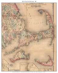
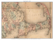
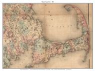
Year - 1861
Author - Walling, H.F.
Original Size - n/a
Print Sizes-
Small - 16 x 20
Medium - 24 x 30
Large - 36 x 45
Publisher/Engraver - unknown
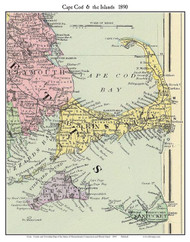
Academic Title - Map of Cape Cod & the Islands 1861
Comments - From the Topographical Map of Massachusetts by H.F. Walling, an important road map of the Cape, with placenames, roads, rivers and every house shown in every town. The original map is a large wall map and has not heretofore been readily available.
Year - 1861
Author - Walling, H.F.
Original Size - n/a
Print Sizes-
Small - 16 x 20
Medium - 24 x 30
Large - 36 x 45
Publisher/Engraver - unknown
Academic Title - Map of Cape Cod & the Islands 1861
Comments - From the Topographical Map of Massachusetts by H.F. Walling, an important road map of the Cape, with placenames, roads, rivers and every house shown in every town. The original map is a large wall map and has not heretofore been readily available.